PARCO NATURALE REGIONALE DEL BEIGUA e Beigua Geoparco
NATURAL PARK OF BEIGUA and Beigua Geopark
AMBIENTE / ENVIRONMENT
![]() Un un dolce altopiano lungo e stretto, con quote che si mantengono costanti oltre i 1000m, e che poi
digradano verso ponente fino ai 514m del Colle del Giovo.
Le cime piů significative sono:
Un un dolce altopiano lungo e stretto, con quote che si mantengono costanti oltre i 1000m, e che poi
digradano verso ponente fino ai 514m del Colle del Giovo.
Le cime piů significative sono:
- Monte Beigua (1286m)
- Monte Ermetta (1267m)
- Monte Grosso (1265m)
- Bric Dame' (1193m)
- Monte Reixia (1182m)
- Monte Rama (1150m)
- Monte Sciguello (1103m)
- Monte Argentea (1086m)
- Bric Del Dente (1109m)
Il gruppo montuoso del Parco ha versanti meridionali aridi e rocciosi con dirupi, costellati da guglie
e solcati da ruscelli e torrenti che formano suggestivi laghetti ed ardite gole come nel caso del Rio Negrone.
Le valli settentrionali, piů umide e meno pendenti,sono invece coperte da estesi boschi. In questi versanti
i torrenti scorrono piů placidi formando contorte anse e fertili piane alluvionali, come per esempio il Torrente Orba
nei pressi di Tiglieto, o scavando canyon rocciosi come il caso del Torrente Gargassa vicino a Rossiglione.
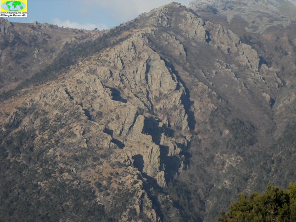 |
| I dirupati versanti meridionali del Parco |
Per le particolari condizioni climatiche e le rapide variazioni di temperatura invernali, e' facile che lungo tutto il crinale si verifichi una fitta nebbia o la "galaverna" che crea sculture di cristalli di ghiaccio su tutto cio' che e' presente.
Un territorio a due passi dal mare nel quale convivono ambienti tipicamente mediterranei assieme ad habitat tipicamente alpini. Una concentrazione di biodiversitŕ unica nel suo genere.
La Zona di Protezione Speciale (ZPS) BEIGUA-TURCHINO ed il Sito di Importanza Comunitaria (SIC) BEIGUA - MONTE DENTE - GARGASSA - PAVAGLIONE, sono parzialmente situati all'interno del Parco e ne ricalcano le caratteristiche generali.
- Monte Beigua (1286m)
- Monte Ermetta (1267m)
- Monte Grosso (1265m)
- Bric Dame' (1193m)
- Monte Reixia (1182m)
- Monte Rama (1150m)
- Monte Sciguello (1103m)
- Monte Argentea (1086m)
- Bric Del Dente (1109m)
The southern slopes of the mountains are barren and rocky with cliffs, dotted with pinnacles and crossed by streams and brooks, which create small lakes and daring gorges as that of Rio Negrone.
The valleys of the northern, more humid and less steep, are covered by extensive forests. In these sides the streams run more placid form twisted loops and fertile alluvial plains, such as the Orba River near Tiglieto, or digging rocky canyons as in the case of the River Gargassa near Rossiglione.
|
| The steep southern slopes of the Park |
For the particular climatic conditions and rapid temperature changes in winter, it often happens that along the ridge occurs a dense fog or "rime", which creates sculptures of ice crystals on everything that is present.
An area just a few steps from the sea, in which, living environments typically Mediterranean together with typically alpine habitats. A concentration of unique biodiversity.
The Area of Special Protection (ZPS) BEIGUA-TURCHINO and ed il Site of Community Importance (SIC) BEIGUA - MONTE DENTE - GARGASSA - PAVAGLIONE, are located partially within the park and have general characteristics similar to those of the park.