Itinerari TREKKING - Liguria
TREKKING routes - Liguria
Liguria-002
"Sentiero Liguria" - Luni - Ventimiglia


DATA/DATE
2013-2016
NOTE GENERALI / GENERAL NOTES
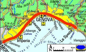
Un nuovo e lunghissimo itinerario Turistico/Escursionistico che ha tutte le carte in regola per diventare una delle spine dorsali della Rete Escursionistica Ligure (R.E.L.). Si chiama "Sentiero Liguria", e da Luni (comune di Ortonovo in provincia di La Spezia) dopo 650 km raggiunge Ventimiglia (provincia di Imperia). In pratica percorre tutta la Liguria mantenendosi lungo la linea della costa, tocca quasi tutti i caratteristici borghi costieri liguri, e permette di immergersi completamente tra i colori i profumi che questa regione regala. Per completare tutto il percorso sono necessario parecchi giorni ma, e' anche possibile effettuare sia brevi tratti di qualche giorno, sia tratti piu' corti di una giornata sola, infatti questo itinerario, mantienendosi sempre a ridosso dei centri abitati e delle strade, permette di scegliere i punti di partenza e arrivo a proprio piacimento.
A new and very long itinerary for Tourists and Hikers, which has all the credentials to become one of the backbones of Ligurian Hiking Network (R.E.L.). It's called "Sentiero Liguria" (Liguria Footh-path), it start from Luni (municipality of Ortonovo in the province of La Spezia) and after 650 km reaches Ventimiglia (Imperia province). In practice, it runs along the Riviera while staying along the coastline, touching almost all the characteristic Ligurian the coastal small towns, and allows you to fully immerse yourself in the colors, scents that this region offers. To complete the entire route several days are needed but it is also possible to walk along short stretches of few days, or walk for a single day only, in fact, this route remains close to the towns and roads, and therefore allows the hiker to choose the points of departure and arrival to your liking.
DATI SINTETICI DEL PERCORSO / ROUTE DATA
Distanza totale / Total Distance: 650 km
Tempo / Time: 35-45 giorni/days
DIFFICOLTA' / DIFFICULTIES
Secondo la scala CAI: compreso tra T ed E (a seconda delle tappe).
Si tratta di un percorso relativamente facile che transita su strade asfaltate a basso traffico, srade sterrate, mulattiere e comodi sentieri.
According to CAI scale: between T and E (depending on the step).
It is an easy route that passes on low traffic road, dirt roads, mule trails and easy trails.
IL SEGNAVIA CHE SI INCONTRA / TRAIL-SIGN
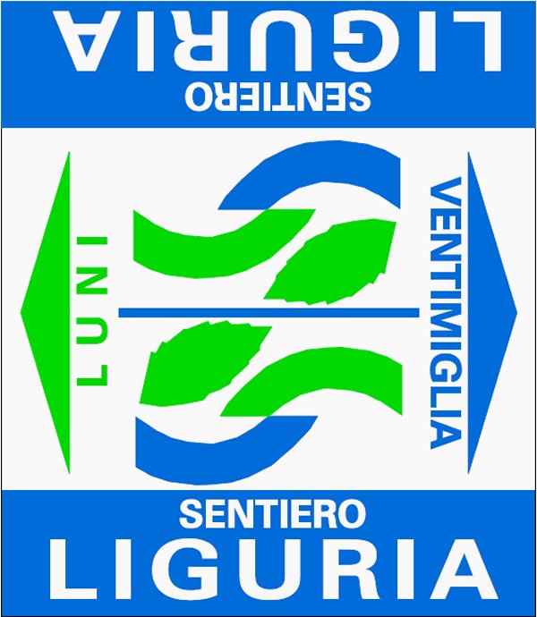
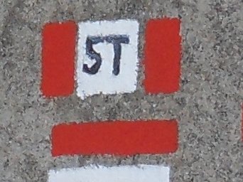
Il segnavia principale di questo itinerario e' costituito da questo logo presente su placchette lungo il percorso e da cartelli presenti ai bivi principali.
Main trail-sign of this route is this logo printed over plates along the route and over tables at main junctions.
ATTENZIONE / WARNING
ATTENZIONE: questo percorso non è sempre sottoposto a costante e periodica manutenzione con ripristino dei segnavia deteriorari e pulizia dei sentieri.
Tale situazione potrebbe rendere questo tracciato non sempre evidente e facile da seguire.
Per questo motivo RACCOMANDO VIVAMENTE DI EFFETTUARE L'ITINERARIO MUNITI DI IDONEA CARTOGRAFIA E/O DI DESCRIZIONE DETTAGLIATA DEL PERCORSO.
WARNING: this path is not always subjected to constant and periodic maintenance with remaking of the damaged trail markers and cleaning of the pedestrian paths.
This situation could make this path not always evident and easy to follow.
For this reason I STRONGLY RECOMMEND YOU TO CARRY OUT THE ITINERARY WITH SUITABLE CARTOGRAPHY AND / OR DETAILED DESCRIPTION OF THE ROUTE.
LE VARIE TAPPE / ROUTE STEPS
Riporto di seguito la sintesi delle varie tappe di questo lungo itinerario. Per le tappe piu' lunghe ho anche riportato la possibilita' di ulteriore suddivisione del percorso, indicando i luoghi intermedi dove e' possibile trovare alloggio. Ovviamente e' possibile dividere il percorso anche in tappe differenti da quelle qui proposte, scelte a proprio piacimento, sostando nei molti luoghi, indicati sulle carte, dove sono presenti strutture ricettive. Per ogni tappa o variante ho anche elencato le varie tavole delle mie carte escursionistiche collana mMOA, che comprendono tale tratto di percorso.
Here below a summary of the various steps of this long route. For longer steps I have also reported the possibility of further subdivision the path, indicating the intermediate places where you can find accommodation. Obviously you can split the path at different steps respect those proposed here, selected to your preferences, stopping in many places, indicated on maps, where there are accommodation. For each steps or variants I also listed the various Maps-Sheets of my hiking maps mMOA type, including that part of the route.
01 - LUNI - BOCCA DI MAGRA
Distanza totale / Total Distance: 11 km
Tempo / Time: 2:75-3:15 ore/hours
Dislivello / Heigh Difference: +0 m / -0 m
Tavole cartografiche delle mie carte escursionistiche collana mMOA che comprendono questo tratto:
Map-Sheets of my hiking maps mMOA type, with this route section:
Tavola/Map-Sheet SentLig-01
....................
....................
I DATI SINTETICI DELLE VARIE TAPPE SONO DISPONIBILI SU SPECIFICA RICHIESTA
THE SYNTHETIC DATA OF THE VARIOUS STAGES ARE AVAILABLE ON SPECIFIC REQUEST
LE CARTE DEL PERCORSO / ROUTE MAPS

Per questo lungo itinerario ho realizzato la cartografia di dettaglio di tutto il percorso.
Si tratta di una serie di carte di tipo Escursionistico, appartenenti alla mia collana
mini MAPPE OUTDOOR ACTIVITIES, in scala 1:25.000 costituite da 50 tavole formato A3.
Su ogni tavola, oltre ai vari sentieri escursionistici, sono presenti indicazioni su:
- Il percorso della Via della Costa
- I vari luoghi che si incontrano lungo l'itinerario
- Dove e' possibile fermarsi per mangiare e per dormire
TRACCIA GPS
Oltre alla Carte Escursionistiche ho anche realizzato la traccia GPS di tutto il percorso, che e' disponibile su specifica richiesta.
For this long journey I made the detailed maps of the entire route.
They are Hiking Maps type mini MAPPE OUTDOOR ACTIVITIES in scale 1:25.000, and they consist of 50 Map-Sheets size A3.
On each Map-Sheet, as well as various hiking trails, there are indications of:
- All Via della Costa path
- Places along the route
- Where you can stop to eat and to sleep
GPS TRACK
In addition to detailed maps, I also created the GPS track of the full path, which is available on request.
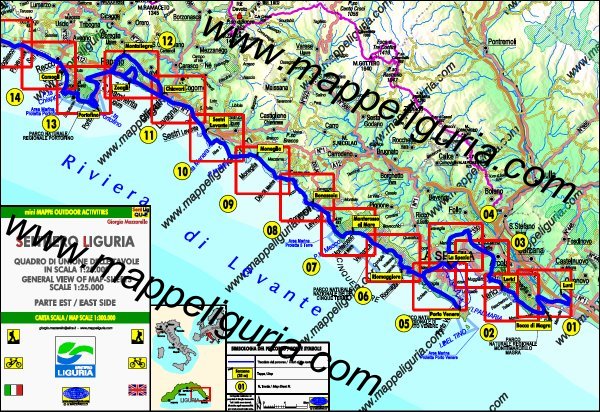
QUADRO DI UNIONE DELLE VARIE CARTE DI DETTAGLIO DEL PERCORSO
PARTE EST - Tavole da 01 a 14
Anteprima delle carte selezionando i riquadri delle varie tavole
GENERAL VIEW OF MAP-SHEETS OF ROUTE
EAST SIDE - Map-Sheets from 01 to 14
Preview of Maps by selecting red box
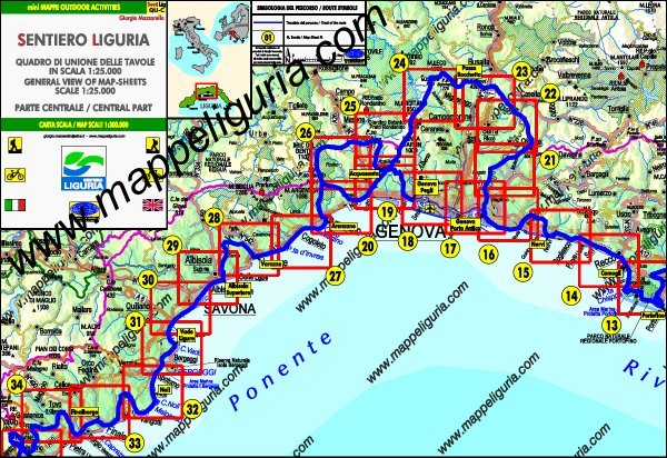
QUADRO DI UNIONE DELLE VARIE CARTE DI DETTAGLIO DEL PERCORSO
PARTE CENTRALE - Tavole da 14 a 34
Anteprima delle carte selezionando i riquadri delle varie tavole
GENERAL VIEW OF MAP-SHEETS OF ROUTE
CENTRAL PART - Map-Sheets from 14 to 34
Preview of Maps by selecting red box
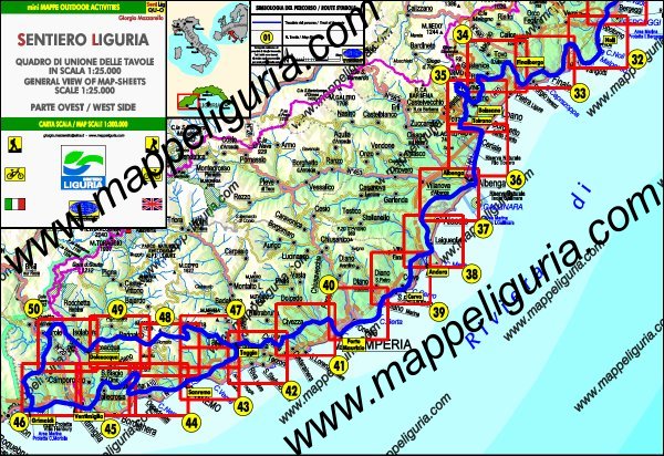
QUADRO DI UNIONE DELLE VARIE CARTE DI DETTAGLIO DEL PERCORSO
PARTE OVEST - Tavole da 32 a 50
Anteprima delle carte selezionando i riquadri delle varie tavole
GENERAL VIEW OF MAP-SHEETS OF ROUTE
WEST SIDE - Map-Sheets from 32 to 50
Preview of Maps by selecting red box
NOTE /NOTICE
Pur avendo prestato la massima attenzione nel disegno della carta e nella tracciatura del percorso, a causa di eventuali errori od imprecisioni o giudizi soggettivi indicati, nonche' della mutevolezza del territorio, della variabilita' delle condizioni meteo, l'autore declina ogni responsabilita' per qualsiasi inconveniente o incidente che potrebbe verificarsi a chi effetua questo itinerario. Chi desidera effettuare questo percorso lo fa a proprio rischio e pericolo.
In the creation of maps and route tracking I have taken utmost care but, due to any possible errors or inaccuracies or subjective judgments indicated, as well as the changing nature of the territory, of the variability of weather conditions, and countless other factors, I decline any responsibility for any incident or accident that could happen to the people that run this route. Those wishing to go this route do so at your own risk.
Chiunque desiderasse avere maggiori informazioni sulle carte di questo itinerario, mi
puo' contattare.
Do you want more information about maps of this route?
Please write me






 Dalla Liguria al Piemonte su di un antico percorso tra storia natura e cultura
